What Causes the Monsoon in India?
The monsoon happens because the Sun drags the tropical rain belt north each summer and the hot Indian landmass pulls in moist ocean winds. Here is the physics, and why the 2026 season ended 13% short.
 By Sushant Kataria· 11 min read
India's monsoon is caused by the Sun's yearly march north, which drags the tropical rain belt over the subcontinent, and by the Indian landmass heating up far faster than the ocean around it. The hot land creates a zone of low pressure that pulls in moist winds from the Indian Ocean, and when those winds rise over the Western Ghats, the Himalayas and the plains, they drop the rain that gives India about three quarters of its water for the year.
That is the short answer. The longer one involves a wind that crosses the equator and bends, a jet stream off the coast of Somalia, a high-pressure cell over Tibet and an ocean current on the other side of the Pacific. It also explains why the 2026 season, which the India Meteorological Department (IMD) closed at just 87 per cent of normal, turned out so dry.
The word and the basic idea
"Monsoon" comes from the Arabic mausim, meaning season. Scientifically, it means a seasonal reversal of winds and the rain that comes with it. A Press Information Bureau backgrounder on the Indian monsoon gives the classic textbook version: in summer the land heats faster than the sea, hot air over the land rises and leaves low pressure behind, and cooler, moisture-laden air from over the ocean blows inland to fill the gap. In winter the pattern flips and the winds blow from land to sea.
For more than 300 years, scientists described the monsoon as exactly that: a giant sea breeze, the same thing you feel on a beach in the afternoon, scaled up to a continent. That picture is useful, but it is incomplete. In a widely cited 2003 review in the Annual Review of Earth and Planetary Sciences, Sulochana Gadgil of the Indian Institute of Science in Bengaluru argued that satellite and ground observations fit a different explanation better: the monsoon is the seasonal migration of the Intertropical Convergence Zone (ITCZ).
The rain belt that follows the Sun
The ITCZ is a band of low pressure near the equator where the trade winds of the northern and southern hemispheres meet. Warm, humid air converges there, rises, cools and forms towering rain clouds. Seen from space, it looks like a belt of thunderstorms wrapped around the planet.
The belt does not stay put. As the Earth's tilted axis swings the overhead Sun between the Tropic of Capricorn and the Tropic of Cancer (the same orbital rhythm that sets the length of the year and why we need leap years), the zone of strongest heating moves with it. The IMD's meteorological glossary states it plainly: this annual oscillation of the "thermal equator" is the cause of the monsoons, and the uneven layout of land and ocean decides how strong the monsoon is in each region.
South Asia is the most dramatic case on Earth because of its geography. A huge continent lies to the north, with the Tibetan Plateau rising more than 4 kilometres into the sky, while to the south there is nothing but open ocean all the way to Antarctica. Each summer the rain belt is pulled unusually far north. The PIB backgrounder notes that by July the ITCZ can reach the Gangetic plains, where it becomes the monsoon trough, the long low-pressure line along which much of north India's rain forms.
Why the land heats faster than the sea
Land and water respond to sunshine very differently. Water has a high heat capacity, it mixes heat downward, and it loses energy through evaporation. Soil and rock do none of that well, so the surface heats quickly.
By May and June, the deserts of northwest India, Pakistan and the Middle East are among the hottest places on the planet. The IMD's frequently asked questions on the monsoon put a number on it: over those arid zones the ground pumps about 160 watts per square metre of heat into the air in June. The result is a shallow, semi-permanent heat low over the region, which the IMD describes as acting like a "suction device" for moist air along the monsoon trough. A strong heat low tends to go with a good monsoon; in 1987, when pressure there stayed above normal, India had a drought.
High above, the heated Tibetan Plateau builds a warm anticyclone called the Tibetan High. Air flowing out of it forms the Tropical Easterly Jet, a fast stream of easterly wind about 14 kilometres up, centred near the latitude of Chennai in July. Shifts in the jet's position, the IMD notes, change where the heaviest rain falls.
How the wind turns southwest
The moist air that soaks India in July actually starts in the southern hemisphere. Around the Mascarene Islands near Madagascar, a high-pressure cell called the Mascarene High pushes air north across the equator.
Once it crosses the equator, the Earth's rotation deflects that air to the right (the Coriolis effect), so a wind that set out blowing from the southeast arrives from the southwest. That is where the name "southwest monsoon" comes from. Along the coast of East Africa, the flow squeezes into a fast, low-level river of air called the Somali Jet, only 1 to 1.5 kilometres above the sea. According to the IMD, it reaches the west coast of India in June, peaks in July, and when it strengthens, so does rainfall over peninsular India.
Sailors understood this wind long before meteorologists did. Greek and Roman ships learned to ride it straight across the Arabian Sea to the Malabar coast, which is how Indian spice became the black gold of Rome.
Where the rain actually falls
The southwest current splits into two branches. The Arabian Sea branch slams into the Western Ghats, and as the air is forced up the slopes it cools and wrings out its moisture. That is why the Konkan and Malabar coasts get torrential rain while the land just east of the mountains, in their rain shadow, stays much drier. The Bay of Bengal branch sweeps into the northeast, where the hills of Meghalaya trap it, then turns west along the Himalayan wall and up the Gangetic plain.
The real rain makers, though, are the monsoon lows and depressions. These are spinning low-pressure systems, often a thousand kilometres or more across, that form over the warm northern Bay of Bengal and drift west across central India, releasing heavy rain as they go. The IMD says about two depressions form in each monsoon month on average. Inside them, convection builds clouds tall enough to reach the top of the troposphere, which over India sits so high that airliners cruising at 35,000 feet have to route around the worst storms rather than climb over them.
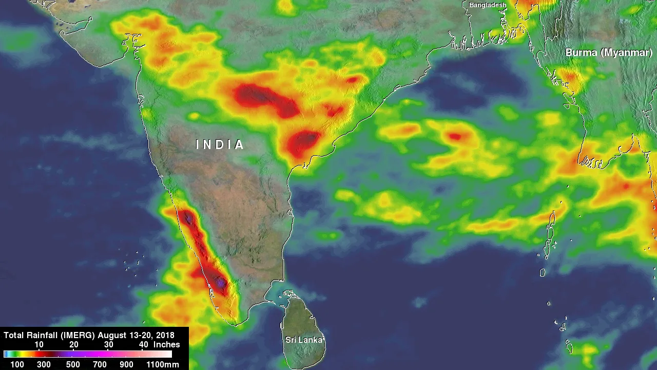
The rain also comes in pulses. Over a few weeks the monsoon trough slides south, bringing "active" spells to most of India, then retreats north to the Himalayan foothills, producing a "break" in which the plains dry out while Assam and Bihar flood. A season can be normal in total and still be miserable for farmers if the breaks fall at the wrong time.
The monsoon calendar, and how 2026 kept it
Because the system is driven by the Sun, its timing is remarkably regular. The IMD's salient features of the 2026 southwest monsoon lists the normal dates: the monsoon reaches the south Andaman Sea around 22 May, sets in over Kerala on 1 June, covers the whole country by 8 July and begins withdrawing from west Rajasthan around 17 September.
In 2026 the monsoon reached the Andaman Sea early, on 16 May, then stalled. It set in over Kerala on 4 June, three days late, and the IMD's own onset forecast of 26 May (plus or minus four days) missed, only the second miss since operational onset forecasts began in 2005. It still covered all of India by 9 July and started withdrawing on 19 September. It had left the entire country by 15 October, the same day the northeast monsoon set in over Tamil Nadu and coastal Andhra Pradesh, The Economic Times reported.
The rain itself fell well short. India received 759.4 mm from June to September against a long period average (LPA) of 868.6 mm, or 87 per cent. That makes 2026 the fourth driest season since 2001 and the 13th driest since 1901, and the IMD classes any all-India total below 90 per cent of LPA as "deficient". As The Hindu noted, it was the weakest monsoon since 2015, which was only a little drier at 758.2 mm.
| Region | Normal (mm) | 2026 actual (mm) | % of normal |
|---|---|---|---|
| All India | 868.6 | 759.4 | 87 |
| Northwest India | 587.6 | 553.0 | 94 |
| Central India | 978.0 | 952.8 | 97 |
| East and Northeast India | 1,367.3 | 1,016.3 | 74 |
| South Peninsula | 716.2 | 542.0 | 76 |
The month by month story was just as uneven: 65 per cent of normal in June, 101 per cent in July, 84 per cent in August and 92 per cent in September. East and northeast India had its driest monsoon since records began in 1901, and 17 of India's 36 meteorological subdivisions ended deficient.

Why some years fail: El Niño and the Indian Ocean
If the Sun drives the monsoon, why does the rain vary so much from year to year? The IMD's FAQ names the two biggest culprits: the El Niño Southern Oscillation (ENSO) in the Pacific and the Indian Ocean Dipole (IOD).
During El Niño, unusually warm water spreads across the central and eastern tropical Pacific. The great rising branch of air that normally sits over Indonesia shifts east, and the sinking air that replaces it suppresses rain over South and Southeast Asia. The PIB backgrounder counts 16 El Niño years since 1950, of which seven brought below-normal monsoon rain to India. The opposite phase, La Niña, usually brings normal or above-normal rain. The IOD works in a similar way within the Indian Ocean: when the western part runs warmer than the eastern part, the monsoon tends to get a boost.
2026 is shaping up as an unusually powerful El Niño year. In its 8 October 2026 ENSO diagnostic discussion, the US Climate Prediction Center reported sea surface temperatures more than 4°C above normal in parts of the eastern equatorial Pacific, with the Niño 3.4 index at +2.1°C, and put an 83 per cent chance on a historic event that would exceed every El Niño since 1950 by the end of the year. The IMD's season review says a weak El Niño developed in June and grew strong by the end of the season, while the IOD stayed broadly neutral, so there was no Indian Ocean help to offset the Pacific drag.
To its credit, the IMD saw the dry season coming. Its April forecast called for 92 per cent of LPA and the May update for 90 per cent, both within their error margins of the final 87 per cent. Its monthly and regional calls were less accurate, especially for a June that turned out far drier than forecast.
Why it matters so much to India
The southwest monsoon delivers roughly 75 to 80 per cent of India's annual rainfall, and 90 per cent or more across large parts of central and northwest India, according to the IMD's Pune climate research centre. It fills reservoirs, recharges groundwater, drives hydropower and waters kharif crops such as rice, cotton, pulses and sugarcane. The IMD tracks a monsoon core zone covering most of the country's rain-fed farmland; in 2026 it got 779.9 mm, just under the lower limit of the normal range.
The effects spread far beyond the farm. A weak monsoon raises food prices, which is why the Reserve Bank of India pointed to the deficient 2026 season as one reason for raising the repo rate in October. A late season also strains power grids as farmers run pumps for irrigation, and it leaves city water boards watching reservoir levels into the summer.
Tamil Nadu is the exception that proves the rule. It sits in the rain shadow of the Western Ghats during the summer monsoon and gets most of its rain from the northeast monsoon between October and December. As the land cools in autumn and the rain belt slides back south, the winds reverse and blow from the northeast across the Bay of Bengal, picking up moisture before they hit the Coromandel Coast.
Three myths about the monsoon
"The monsoon is just rain." It is a wind system first. The rain is what happens when those winds meet mountains, low-pressure systems and the rising air of the ITCZ.
"A normal monsoon means every region is fine." All-India totals hide huge gaps. In 2026, Odisha had excess rain while east and northeast India had their driest season on record.
"El Niño always means drought." It raises the risk, but fewer than half of El Niño years since 1950 brought below-normal rain to India. The Indian Ocean Dipole, slower swings such as the Pacific Decadal Oscillation and the timing of breaks all matter too.
So what causes the monsoon in India? The Sun pulls the tropical rain belt north, the hot land and the high Tibetan Plateau build low pressure over South Asia, and a cross-equatorial wind bends into a southwesterly that carries the Indian Ocean's moisture inland. The physics repeats every year with clockwork regularity; how much rain it brings depends on oceans thousands of kilometres away, which is why a strong Pacific El Niño left India 13 per cent short in 2026.